Penarth Dock, South Wales - the heritage & legacy . . . |
Penarth Dock, South Wales - the heritage & legacy . . . |
|
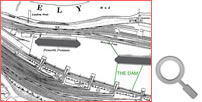
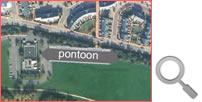
Volume Five - The Age of Decline & Crass Stupidity - Where is the final resting place of the pontoon ? . . .
The pontoon is probably resting some 250 metres further down the dock in an south-easterly direction. The green line represents the dam location based upon the 1970-1974 OS map. Since that time the area has seen a great deal of change so I thought it appropriate to include some Google Earth maps of the locality.
|
|||||||||||
| Introduction | |||||||||||
| Contents | |||||||||||
| Search this site | |||||||||||
| Contributions | |||||||||||
| Links | |||||||||||
| Recent Updates | |||||||||||
|
|||||||||||
| | volume 05 | chapter 05 | page 01 | << previous page << | index to volume five | >> next page >> | | |||||||||||