Penarth Dock, South Wales - the heritage & legacy . . . |
Penarth Dock, South Wales - the heritage & legacy . . . |
|
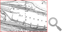
Volume One - Into the Victorian Age - The graving dock and the growth of the coal trade . . . A good description of the theory of the graving dock may be found in a publication defending their specialty, that of designing floating docks, and clearly outlining the disadvantages of the graving dock, by Clark & Stanfield [020] in 1901:- "The graving dock is, in its simplest sense, nothing more than a hole dug out of the foreshore below high-tide level with its sea end closed by a caisson or gate. A vessel is floated into this excavation and the end closed by a gate, and when the contained water is pumped out of the pound or interior of the excavation empty, the bottom of the vessel can be got at . ." |
|||
| Introduction | |||
| Contents | |||
| Search this site | |||
| Contributions | |||
| Links | |||
| Recent Updates | |||
|
|||
| | volume 01 | chapter 06 | page 010 | << previous page << | index to volume one | >> next page >> | | |||