Penarth Dock, South Wales - the heritage & legacy . . . |
Penarth Dock, South Wales - the heritage & legacy . . . |
|
Volume Twelve - Pre-Victorian to the Present Day - further aspects - The Bristol Channel District Guide - selected articles - [1934 Edition] . . . .
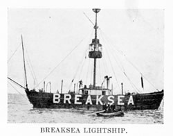
Six miles beyond Breaksea a portion of the village of Llantwit can be seen and a little beyond is St. Donat's Castle, with its well-known headland of Nash two miles farther on. I t is very dangerous owing to the long tongue of sand extending eleven miles in a down-channel direction from it. The two lighthouses, one of which is now obsolete and the light discontinued, are for the purpose of indicating the presence and direction of this shoal to those passing up or down. A heavily laden vessel with a large draught of water going in our direction, say to Swansea, would keep outside of the Nash Sands, and, a little lower, the Scarweather Sands with a Lightship off the western edge of the shoal ; but we can take the narrow passage just off the point, and save twenty miles or so. The castle that stands out to view three miles beyond Nash is Dunraven Castle, and the high, breezy-looking ridge, with the sprinkling of houses upon it beyond Dunraven Castle, is Southerndown, a quiet watering-place. Porthcawl, with the Tusker Rock lying near it, four miles farther on, is a livelier and larger watering-place. It is a bracing spot and the bathing beaches are extensive and perfectly safe. |
|||||
| Introduction | |||||
| Contents | |||||
| Search this site | |||||
| Contributions | |||||
| Links | |||||
| Recent Updates | |||||
|
|||||
| | volume 12 | chapter 18 | page 07_040 | << previous page << | back to chapter index page | >> next page >> | | |||||