Penarth Dock, South Wales - the heritage & legacy . . . |
Penarth Dock, South Wales - the heritage & legacy . . . |
|
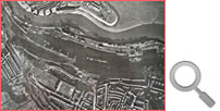
Volume Twelve - Pre-Victorian to the Present Day - further aspects - Aerial Views - 1946 to 1981 . . . The Central Register indexes all aerial survey cover of Wales flown by the RAF, Ordnance Survey and commercial aerial survey companies, and is a comprehensive source about aerial photography of Wales advising all interested users. The Assembly holds an extensive collection of aerial photographs covering Wales from 1940 to present day at a variety of scales. During March 2024, I was given the privilege of viewing the following series of aerial photographs which are in the care of Mr. Stuart Jones, the Penarth Marina Manager. Stuart is a civil engineer who worked upon the barrage and conversion of the Penarth Dock to the Penarth Marina. [1292] We commence just after the end of WWII, during December 1946, and travel through time in a series of steps until June 1981.
|
|||||||||
| Introduction | |||||||||
| Contents | |||||||||
| Search this site | |||||||||
| Contributions | |||||||||
| Links | |||||||||
| Recent Updates | |||||||||
|
|||||||||
| | volume 12 | chapter 12 | page 010 | << previous page << | index to volume twelve | >> next page >> | | |||||||||